If Day 1 had been uneventful, Day 2 was even more so. In fact, it was so uneventful, I can describe it in one sentence. One that many a rider will recognize: Eat, sleep, ride, repeat. Well, here, let’s take a look together.
And now I’m in Grand Forks, North Dakota. That was easy. Let’s see what Day 3 has in store.
Now Day 3 has me traveling from Grand Forks, North Dakota to Havre, Montana. I am finally going to get to ride on Highway 2. I’ve looked forward to riding Highway 2 for a long time. It is the northern-most east-west highway in the United States, spanning over 2,500 miles. It basically runs from the state of Maine all the way to the state of Washington. It is mostly a divided highway, four lanes in all. And looking at it on a map, I imagined it to be a whole lot more exciting than it really is.
I guess I imagined the scenery would gradually change as I left the land of a 10,000 lakes and rode west towards the land of big sky and later the Rocky Mountains. Across North Dakota, I imagined fields of wheat, golden in color, gently waving back and forth in the gentle breeze. All amber waves of grain or however that phrase goes. Nothing holding me back. Just a relaxing ride enjoying the scenery and thinking about the fact that for the next 30 days, I was on my own, just me and my motorbike. And I was riding to Alaska. Yea, Alaska! How cool is that? How many people can say they did that? How long have I waited to do this? And now I was actually doing it. And today would be the first day where I actually felt like I was on the trip. The scenery would be changing. The speed limit was 70 mph. And besides, today I would be visiting my first landmark stop: the Geographical Center of North America. How exciting is that!
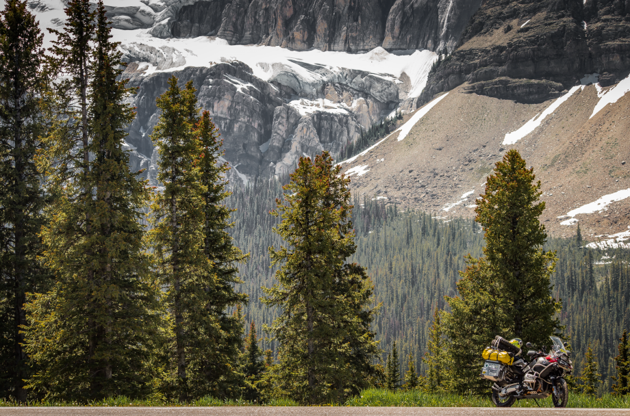
 Highway 2. Well, okay, maybe not to you, but as a traveler, I would now be able to check that one off my bucket list. I have been on the highest paved road in North America. I hope to ride to the northernmost point on a continuous road in North America on this trip. I hope to hit the westernmost continuous road in North America also while I’m in Alaska. Of course I have already been to the four corners in the southwestern area of the US.
Oh, I screwed up yesterday! I forgot I wanted to check out the 2,063 foot tall KVLY-TV Antenna, the tallest man-made structure in the western hemisphere and the third tallest structure in the world. Yep, a TV tower in North Dakota. Road trip – for another day. Sigh.
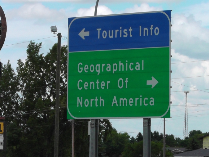
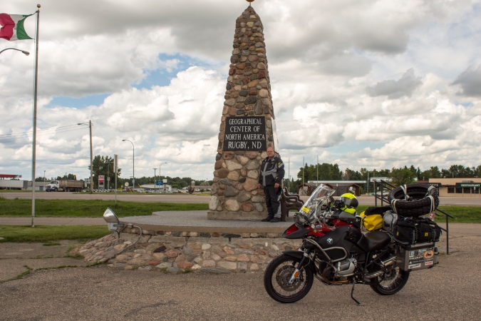
I know your jealous of my being able to check out all of these fascinating places. I’m sure they’re on your bucket list, aren’t they? Yep, I’m livin’ large. Okay, maybe not. Well, let’s take a look at my visit to the Geographical Center of North America Monument.
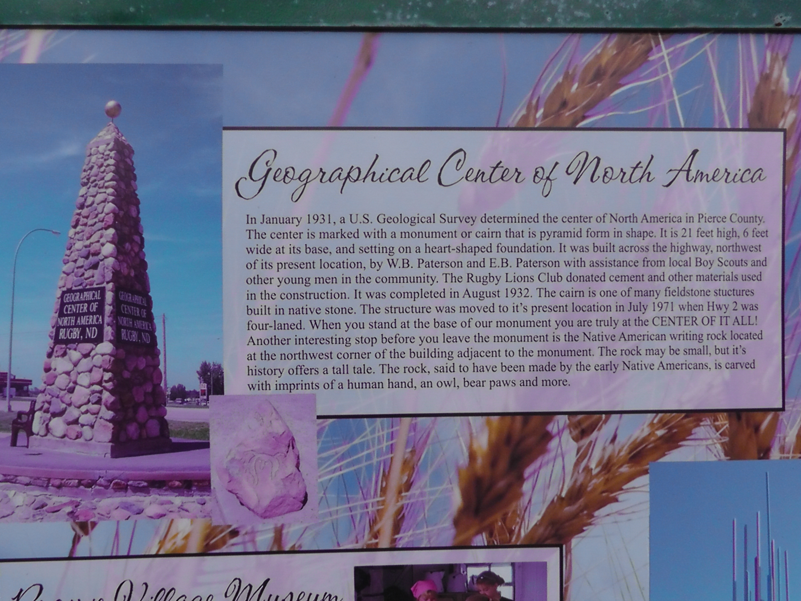 The monument is right off of Highway 2 in Rugby, North Dakota, in the middle of a parking lot of some type of store. I say some type, because currently there is no active business in the building. But none the less, this is a pretty popular landmark. And I bet you might not have even heard of it.
My plan was to zip in, take a picture or two, hop back on the bike and continue on my merry way. But as I pulled into the parking lot where the monument is situated I see a bus with about 15 people mulling around it. They are from Florida. They are missionaries who come up here each year to visit some of the Indian reservations that populate the area. I didn’t take any pictures of them for myself, but I did take a picture of all of them together with their camera. This would be a common theme throughout this trip. I take pictures for other people, but don’t take pictures of them for myself.
Alright, side bar time. Those of you who know me know that I’ve not been one for taking a lot of vacations. I usually go on one about every ten years. So the last couple of years I have begun trying to take more. But this whole taking pictures of other people whilst on my vacation is alien to me. Yet, when I look at other traveler’s pictures, I see lots of pictures of them, or pictures of them meeting other people, or just other people. And a few scenery type pictures are thrown in as well. My vacation pictures are the opposite. Scenery pictures, and if someone else shows up in a picture, well they must have slipped in when I wasn’t paying attention. I think I better work on that a bit.
Meanwhile, back at the monument, I’m getting these bus people on their way. I wave goodbye, and begin unloading camera equipment from the bike. Tripod, DSLR, lens for DSLR, filter, etc. Here comes a guy on a Harley. He parks right next to my bike, which I have just relocated to front of the monument for my picture. Now he’s getting on his cellphone and talking to someone. I don’t want him in my picture. Why did he park next to my bike?
So picture taking is once again on hold while I figure out what to do with him. Along comes two other guys on Harleys. Now we’re all parked in front of the monument. Do I take a picture of that? No! Now a car shows up and a family hops out and is wandering all around. They eventually all end up standing with us bikers, assuming we all know each other, and asking us questions about where we’re going, coming from, how long have we been on the road, etc.
Now you might think that I was getting frustrated with all of this. Afterall, I just wanted to get my picture and move on. But you would be wrong. This is exactly why I like to travel by motorbike. People approach you and you get to meet all kinds of interesting people and hear their stories as well. And this was in my mind as we all stood around, laughing at the fact that we were all standing in front of a monument that is incorrectly placed at the geographical center of North America. And we came here on purpose! I was enjoying this immensely.
Side bar – again. So let’s get this straight. I’m on a trip. I stop at the monument to take a picture. In the process, I meet all these other people. The meeting of the people becomes the story. Not my picture of me standing in front of the monument. I should have pictures of all of these people to share with you. But I don’t. So since I did not take pictures of my fellow riders, or anyone else for that matter, I will share one story with you from one of the riders.
Back to the monument. This fellow is from near Anchorage, Alaska. Did I tell you I’m really bad with remembering names too? He had decided to buy a Harley. He found one in Florida. He is a truck driver. So he drove his truck to Florida, picked up his bike, and was now riding it back to home in Alaska. He then would be riding back down to Florida with another truck driver and picking up his truck to drive back home in Alaska. Huh?
Now I’m not going to ask a lot of questions here, but you gotta wonder just how much money did this guy spend on fuel to drive his semi-truck to Florida and ride the bike back to Alaska. Then he is going head back down to Florida and drive his semi truck back to Alaska. And this was a used Harley, not a new one. Didn’t seem to be anything special about it. He did take a picture of me at the monument. Here it is.I hope he rides his bike better than he takes pictures.
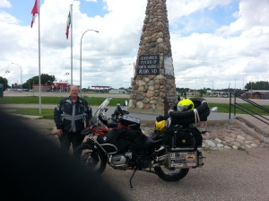
So I finally did get my pictures at the monument.
We all rode across the street to a local gas station to grab a drink together where we met up with a couple other riders on Honda Goldwings, coming from Alaska. As we all stood around and got aquainted we began discussing the Dalton Highway. These two Goldwing boys had just been up that way. Well, they had ridden up to the Arctic Circle anyway. Seems there might be some issues on the Dalton I might need be aware of.
They said it was caused by global warming. Maybe it was just springtime in Alaska. But either way, the road was a bit unfriendly. Or at least that is what they had heard. All was fine until you got north of Coldfoot. Then it went rapidly downhill. Water standing on the road. Roadway slick as snot. Road being torn up and re-graded. Long waits for escort trucks to take you through the construction. There was even word that people on big bikes were being advised not to ride north of Coldfoot. The traveling was just too difficult on big bikes. And guys on small bikes said it was the worst they’d seen in years. All in all, a lot of doom and gloom. And I needed to ride this rode to get to Deadhorse.
Deadhorse. What is it? Where is it? Well obviously it is in Alaska since this blog is about my ride to Alaska. If you want to know a lot about Deadhorse, check it out on the internet. I don’t want to bore you with the details. But this destination, is on many motorcycle rider’s bucket lists. Why? Because it is not an easy place to ride a motorbike.
If you are going to ride a motorbike to northern Alaska, the roads you have to choose from are only going to be one: the Dalton Highway. Maybe you know it as the Haul Road if you’re a fan of the TV Show Ice Road Truckers. This road is 413 miles long. It is built upon the permafrost. Much of it is gravel. Its sole purpose is to provide a supply route to and from Prudhoe Bay, one of the largest oil reserves in the United States.

Looking North On the Dalton Highway July 8, 2013
Along the Dalton Highway runs the Trans-Alaska Pipeline. It runs from Prudhoe Bay all the way south to Valdez, Alaska. Just over 800 miles. Part of it is underground. But most of it is above ground. It is one of the world’s longest pipelines. It has carried over 26 billion barrels of oil since it was completed in 1977. But the pipeline is just part of the enticement of riding the Dalton.
This road is considered one of, if not the, most dangerous road in the United States, and likely, the whole of North America. I will tell you more about it later. But for now consider this. 413 miles long. Only two locations to get fuel should you need it. Same with food or other supplies. No cellphone service. If you breakdown, you are on your own against brown, black and grizzly bears, moose, and other wild animals. You have virtually no contact with the outside world while you travel it. The main traffic is huge semi trucks hauling supplies to and from Prudhoe Bay. And they aren’t likely to stop and help you if you break down.
And then there is the weather. It’s Alaska! It rains a lot. Snows a lot. It really can be a bit challenging some of the time. And cold too. Some of the world’s coldest temperatures ever recorded have been recorded near the Dalton. So if you have your rain suit, gloves, some boots, and maybe a coat and hat, let’s get back to my trip.
There is a small window of about six weeks when the weather is most favorable for motorbike riders who choose to take on the Dalton. Mid-June to Mid July. Actually, the best time is about the last week of June or first week of July. Before that, you will be fighting snow. After that, you will be fighting the rainy season, which makes the road nearly impassable on motorbikes. Oh, there is also the mosquitos, or mozzies as many call them. They are big, and there are many. More on that later too.
So after hearing the horrors stories from these two fellows, I decided to just file that information in the back of my brain and continue onward. If I ran into problems up north, I would deal with them as I came upon them. But for now, I am going to refill my water bottle and hit the road. I’ve got 637 miles to cover today and I’m not even half-way yet. But I have another surprise coming up later today. And I will discuss that in my next blog.

What a bike! What a journey! Enjoy… now I am jealous…
LikeLike
I just followed on his blog one rider from CA to Deadhorse. He came back down yesterday right passed my cabin…he reported some snow and definitely cool weather.
LikeLike
Here is the link to the other bike riders blog on WordPress about his travel on the Dalton
http://arnemann.wordpress.com/2013/08/25/day-9-crossing-arctic-circle-and-reaching-the-top-of-north-america-and-the-arctic-ocean-510-miles-from-fairbanks-to-deadhorse-prudhoe-bay-alaska-23-aug-13/
LikeLike